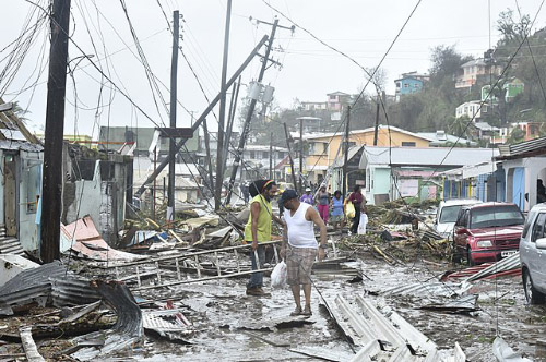
The storm made landfall on Puerto Rico on Wednesday, September 20 as a Category 4 hurricane with maximum sustained winds of 155 mph.[95] A sustained wind of 64 mph (103 km/h) with a gust to 113 mph (182 km/h) was reported in San Juan, Puerto Rico, immediately prior to the hurricane making landfall on the island. After landfall, wind gusts of 109 mph (175 km/h) were reported at Yabucoa Harbor and 118 mph (190 km/h) at Camp Santiago.[96] In addition, very heavy rainfall occurred throughout the territory, peaking at 37.9 in (962.7 mm) in Caguas.[97] Widespread flooding affected San Juan, waist-deep in some areas, and numerous structures lost their roof.[95] The coastal La Perla neighborhood of San Juan was largely destroyed.[98] Cataño saw extensive damage, with the Juana Matos neighborhood estimated to be 80 percent destroyed.[99] The primary airport in San Juan, the Luis Muñoz Marín International Airport, was slated to reopen on September 22.[100]
Storm surge and flash flooding—stemming from flood gate releases at La Plata Lake Dam—converged on the town of Toa Baja, trapping thousands of residents. Survivors indicate that flood waters rose at least 6 ft (1.8 m) in 30 minutes, with flood waters reaching a depth of 15 ft (4.6 m) in some areas. More than 2,000 people were rescued once military relief reached the town 24 hours after the storm. At least eight people died due to the flooding while many are unaccounted for.[101]
Originating from a tropical wave, Maria became a tropical storm on September 16, east of the Lesser Antilles. Highly favorable environmental conditions allowed the storm to undergo explosive intensification as it approached the island arc. The hurricane reached Category 5 strength on September 18 just before making landfall on Dominica, becoming the first Category 5 hurricane on record to strike the island. After weakening slightly due to crossing Dominica, Maria achieved its peak intensity over the eastern Caribbean with maximum sustained winds of 175 mph (280 km/h) and a pressure of 908 mbar (hPa; 26.81 inHg), making it the tenth-most intense Atlantic hurricane on record. On September 20, an eyewall replacement cycle took place, weakening Maria to a high-end Category 4 hurricane by the time it struck Puerto Rico. Interaction with land further weakened the hurricane, though it regained some strength as it moved northeast of The Bahamas. Moving slowly to the north, Maria gradually degraded and weakened to a tropical storm on September 28. Embedded in the westerlies, Maria accelerated toward the east and later east-northeast over the open Atlantic, becoming extratropical on September 30 and dissipating by October 3.
As of December 9, at least 112 people were confirmed killed by the hurricane: 64 in Puerto Rico, 31 in Dominica, 5 in the Dominican Republic, 4 in the contiguous United States, 3 in Haiti, 2 in Guadeloupe, and 3 in the United States Virgin Islands. Dozens of others, mostly in Dominica and Puerto Rico, are still missing. The death toll in Puerto Rico is believed to be far higher than the official toll, with estimates of the actual loss of life ranging from 500 to more than 1,000. Maria wrought catastrophic damage to the entirety of Dominica, which suffered an island-wide communication blackout. Much of the housing stock and infrastructure were left beyond repair, while the island's lush vegetation had been practically eradicated. The islands of Guadeloupe and Martinique endured widespread flooding, damaged roofs and uprooted trees. Puerto Rico suffered catastrophic damage, including destruction of its previously damaged electrical grid. For weeks in Maria's wake, most of the island's population suffered from flooding and lack of resources, compounded by the slow relief process. Total losses from the hurricane are estimated at upwards of $91.61 billion (2017 USD), mostly in Puerto Rico, ranking it as the third-costliest tropical cyclone on record.


).jpg)